The Ecuador Volcano Supersite
The Ecuadorian volcanoes have been selected as a Volcano Supersite in the framework of the Geohazard Supersites and Natural Laboratories (GSNL) of the Group on Earth Observation (GEO). Through GEO, several space agencies coordinated by the Committee of Earth Observation Satellites (CEOS) provide satellite imagery to the Instituto Geofísico with three objectives: (1) volcano monitoring from space, (2) promote and facilitate fundamental research by the international scientific community, (3) access to satellite imagery in the event of disasters. The space-based and ground-based monitoring systems are part of the Global Earth Observations System of Systems (GEOSS). For more information on the GSNL initiative click https://www.earthobservations.org/gsnl.php, and for more information on GEO click https://www.earthobservations.org/index.php
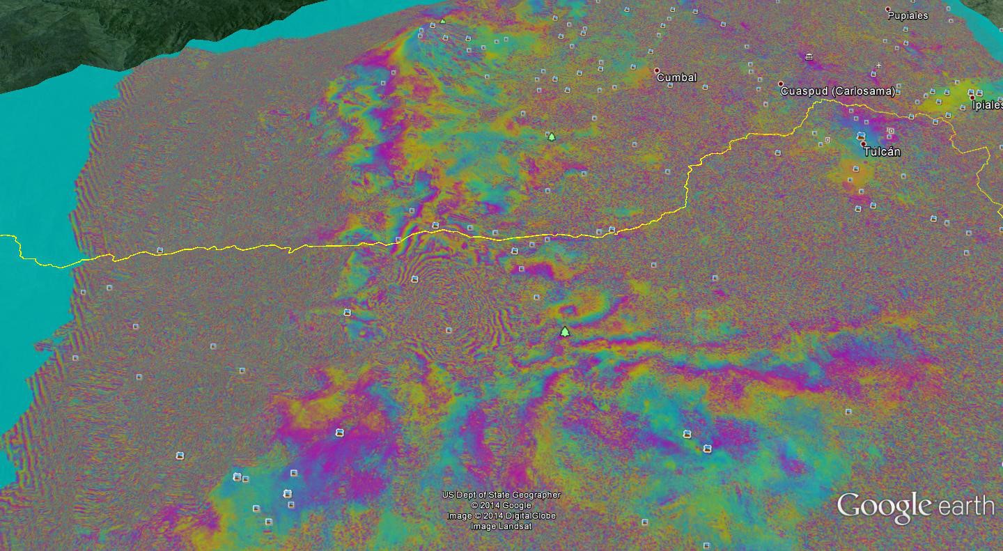
Interferometric synthetic aperture radar (InSAR) is used to detect ground displacements caused by subsurface magma movement and magma accumulation. SAR imagery can identify changes in the crater or at the summit of a volcano. SAR is an active remote sensing technique which can see through meteorological and eruption clouds.
At this time Cotopaxi and Tungurahua volcanoes are imaged by the TerraSAR-X satellite of the German Space Agency and by the Cosmo-Skymed satellites of the Italian Space Agency. In addition, the volcanoes are observed routinely by the European Space Agency’s Sentinel-1a sensor and by Japan’s ALOS-2 and occasionally by NASA’s airborne UAVSAR.
Access to space data
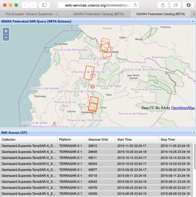
TerraSAR-X
The data is openly accessible from the German Space Agency’s Supersite web portal from here-3. It can also by accessed using the CEOS/Unavco Seamless SAR archive (SSARA) using the following URL:
http://web-services.unavco.org/brokered/ssara/gui?collectionName=Geohazard.Supersite.TerraSAR-X_SSC&intersectsWith=POLYGON((-79.2 1.4,-77.7 1.4,-77.7 -3.4,-79.2 -3.32,-79.2 1.4))&output=map
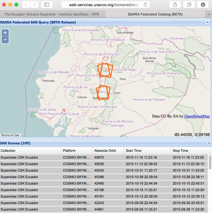
Cosmo-Skymed
The imagery has been made accessible by ASI to the Supersite Coordinator Patricia Mothes and to her research team members. To request access to the data, interested scientists are invited to contact Patricia (Esta dirección de correo electrónico está siendo protegida contra los robots de spam. Necesita tener JavaScript habilitado para poder verlo.). You will be required to read, initial each page, and sign the last page of ASI's license agreement for CSK data (which Patty will send to you upon receiving your access request). The agreement will then need to be sent to Simona Zoffoli, who is coordinating ASI's collaboration with the Supersites project (Esta dirección de correo electrónico está siendo protegida contra los robots de spam. Necesita tener JavaScript habilitado para poder verlo.). Upon approval, you will receive the credentials for data access. The imagery is available via SSARA from:
http://web-services.unavco.org/brokered/ssara/gui?collectionName=Supersites CSK Ecuador&output=map
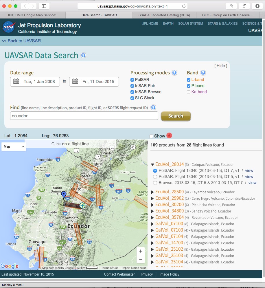
UAVSAR
UAVSAR data can be downloaded from this search interface. To get a list of Ecuador scenes, search on “Ecuador”.
Access to in-situ data
The IG invites the international scientific community to participate in collaborative research projects. Users of IG geophysical network-based data agree (i) to communicate findings and interpretations to the IG, (ii) to give proper attribution and (iii) to refrain from making public predictions or forecasts of volcanic activity, pursuant to established international protocols (IAVCEI, 1999, Professional conduct during volcanic crises, Bull. Volcano. 60: 323-334).
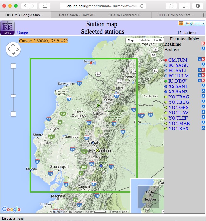
Seismic data
Some data of the seismic networks are available from the IRIS data portals, whereas other data are available on request by contacting Mario Ruiz (Esta dirección de correo electrónico está siendo protegida contra los robots de spam. Necesita tener JavaScript habilitado para poder verlo.).
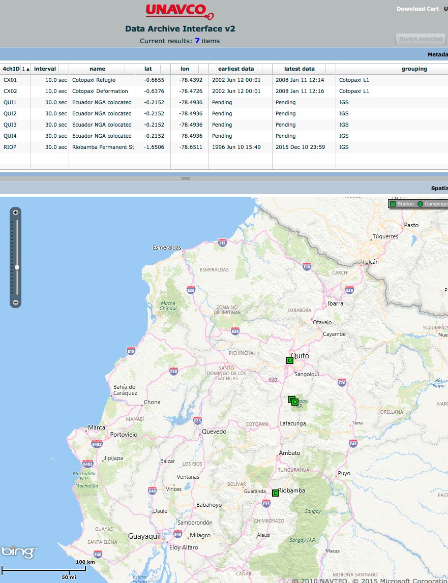
GNSS data
Some data of the GPS networks are available from Unavco. Others can be requested from Patricia Mothes (Esta dirección de correo electrónico está siendo protegida contra los robots de spam. Necesita tener JavaScript habilitado para poder verlo.).
Tilt, gas, thermal data
These data sets are available on request from Patricia Mothes- tilt (Esta dirección de correo electrónico está siendo protegida contra los robots de spam. Necesita tener JavaScript habilitado para poder verlo.), Silvana Hidalgo- gases, Esta dirección de correo electrónico está siendo protegida contra los robots de spam. Necesita tener JavaScript habilitado para poder verlo. and Patricio Ramon-thermal, Esta dirección de correo electrónico está siendo protegida contra los robots de spam. Necesita tener JavaScript habilitado para poder verlo., respectively (there is no international data sharing infrastructure).
Monitoring data products
We are currently in discussion with the World Organization of Volcano Observatories (WOVO) about participation in WOVOdat
Links:
here-1: http://www.earthobservations.org/gsnl.php
here-2: http://www.earthobservations.org
here-3: https://supersites.eoc.dlr.de
this search interface: http://uavsar.jpl.nasa.gov/cgi-bin/data.pl?itext=1
Preliminary results
This section provides examples of research results obtained using the CEOS satellite data. Some of the results were obtained using data from the CEOS volcano pilot, which is a similar preceded the Supersite effort.
Publications & Examples
Morales Rivera, A., Fabien Albino, Falk Amelung, Patricia M Gregg and Patricia A Mothes. (2015) Volcano Deformation Sources at Tungurahua Volcano from Finite Element Methods and Multidisciplinary Data Integration. AGU abstract, ID#: 72627,
San Francisco CA.
Morales, A., Amelung F., Mothes P., (Submitted). Volcano Deformation Survey over the Northern and Central Andes with ALOS InSAR Time Series.
Susanna K. Ebmeier, John R. Elliott, Jean-Mathieu Nocquet, Juliet Biggs, Patricia Mothes, Paúl Jarrín, Marco Yépez, Santiago Aguaiza, Paul Lundgren & Sergey Samsonov
Bidirectional feedback between magmatic intrusion and moderate earthquake (submitted)
Biggs, J., P. Mothes, M. Ruiz, F. Amalung, T. H. Dixon, S. Baker and S_H. Hong, 2010. Stratovolcano growth by co-eruptive intrusion: The 2008 eruption of Tungurahua, Ecuador. Geophysical Research Letters, Vol. 37, L21302, doi: 10.1029/2010GL044942
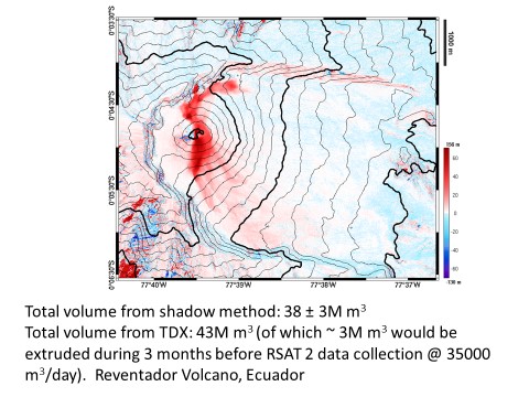
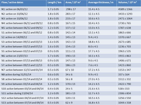
There are also PhD thesis of Cyril Muller and David Arnold (University of Bristol) who are using SAR images of Tungurahua and Reventador volcanoes.
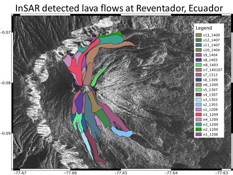
Courtesy of David Arnold, Bristol, Dec., 2015.
Courtesy of Paul Lundgren, JPL-NASA.
------------------------------------------------------------------------
Falk Amelung
Professor
Department of Marine Geosciences
Rosenstiel School of Marine and Atmospheric Sciences
University of Miami
4600 Rickenbacker Causeway
Miami, FL 33149
USA
Tel: 305 421 4949
E-mail: Esta dirección de correo electrónico está siendo protegida contra los robots de spam. Necesita tener JavaScript habilitado para poder verlo.
http://www.geodesy.miami.edu/
http://www.rsmas.miami.edu/personal/famelung/
&
Patricia Mothes
Head of Volcanology
Instituto Geofísico
Escuela Politécnica Nacional
Quito, Ecuador
Telf: 593-22-225-655 office;
593-991-374-911 Cell
E-mail: Esta dirección de correo electrónico está siendo protegida contra los robots de spam. Necesita tener JavaScript habilitado para poder verlo.
http://www.igepn.edu.ec
- Está aquí:
-
Inicio

-
Nosotros
-
Proyectos
-
The Ecuador Volcano Supersite
- Mostrando artículos por etiqueta: GEO
© 2025 Instituto Geofísico - EPN

Inicio | Escuela Politécnica Nacional | Correo Institucional
Ladrón de Guevara E11-253, Aptdo. 2759 Quito - Ecuador.
Teléfonos: (593-2)2225655 ; (593-2)2225627 Fax: (593-2)2567847