
Servicios (36)
Servicios de la IGEPN
Subcategorías
Vulcanología (2)
Esta categoría permite agrupar articulos relacionados con los volcanes
Sismología (4)
Esta categoría permite agrupar articulos relacionados con los sismos
El Instituto Geofísico de la Escuela Politécnica Nacional, pone a su disposición sus cuentas de redes sociales con el objetivo de difundir a través de estos canales la información del día a día que se presenta en los volcanes y la actividad sísmica de nuestro país.
Es importante mencionar que en caso de existir una CRISIS el mejor medio para mantenernos comunicados con la comunidad ecuatoriana serán las redes sociales, donde usted podrá recibir información en línea.
Búscanos en:

CENIZA VOLCÁNICA
LOS PIROCLASTOS
El magma esta hecho de roca parcialmente derretida que se encuentra almacenado en el interior de la tierra. Al igual que las gaseosas o el agua mineral, el magma contiene muchos gases disueltos en su interior, que crean mucha presión. Durante las erupciones, estos gases son expulsados violentamente, haciendo que la roca se rompa en millones de pedazos de distintos tamaños. Todos estos fragmentos de roca son llamados piroclastos. Su nombre viene del latín:
PIRO= fuego CLASTO= pedazo
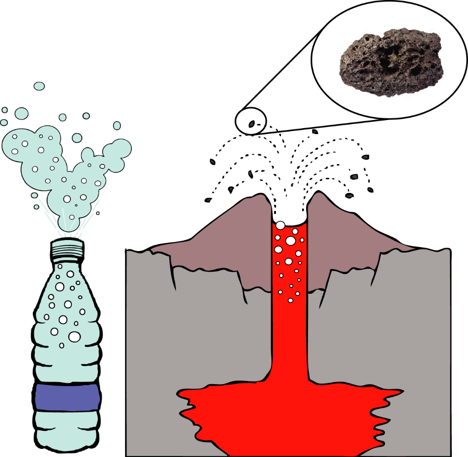
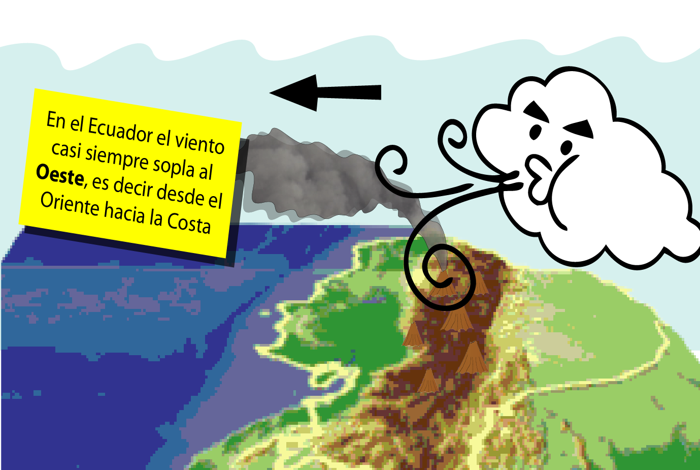
Los fragmentos más grandes y pesados pueden alcanzar el tamaño de un automóvil; debido a la gravedad siempre caerán cerca al cráter. Por otra parte, los fragmentos más pequeños y ligeros pueden ser arrastrados por el viento, llegando a caer en sitios lejanos.
Las caídas de ceniza pueden bloquear la luz del sol, causando oscurecimiento del cielo, es común observar rayos durante grandes emisiones de ceniza.
LA CENIZA
Se llama ceniza a los piroclastos que tienen un tamaño menor a 2 mm.
Su Tamaño
La ceniza tiene varios tamaños, que pueden ser fácilmente entendidos por comparación con objetos del día a día. La ceniza fina se parece muchos a los granos de harina de trigo, la ceniza de grano medio es similar a los granos de sal y finalmente la ceniza gruesa es más parecida a los granos de azúcar.
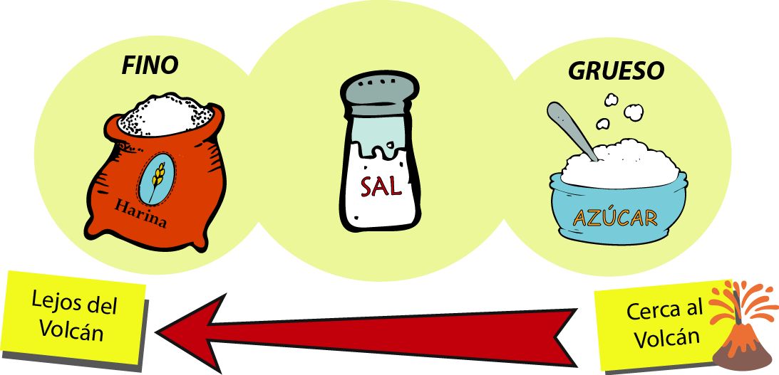
La distancia a la que viajan los granos de ceniza depende de su tamaño. La ceniza gruesa cae siempre cerca del volcán, pero la ceniza fina puede viajar a largas distancias.
La ceniza fina puede resultar especialmente problemática, no solo porque puede alcanzar distancias más largas sino que además se queda suspendida en el ambiente donde es fácilmente respirada.
La ceniza fina tiene gran capacidad para absorber agua y aumentar su peso; por lo que, al acumularse en los techos, puede hacer que colapsen, causando daño a las personas
Su Color
Otras características de la ceniza como el color, son también importantes pues ofrecen pistas valiosas a los científicos sobre los procesos que están ocurriendo en el volcán o sobre sus fases eruptivas.

Se distingue, por ejemplo, ceniza de color negro, blanco, gris y rojo. ¡RECUERDA! Esta información es muy valiosa para los científicos y autoridades a la hora de reportar una caída de ceniza en tu comunidad.
¿QUÉ HACER EN CASOS DE CAÍDA DE CENIZA?
La ceniza puede resultar peligrosa para la salud. Puede irritar la piel y sobretodo causar problemas respiratorios. Los niños, personas con problemas respiratorios y ancianos son especialmente vulnerables.
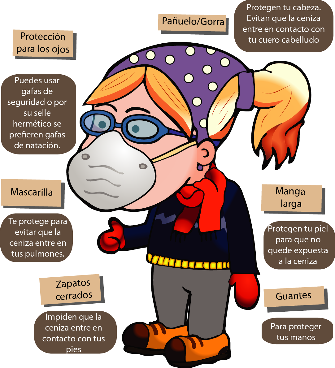
En caso de caída de ceniza no olvides protegerte usando:
Elige Bien Tu Mascarilla
Recuerda que no todas las mascarillas te ofrecen la misma protección. Es conveniente buscar mascarillas que protejan contra material particulado (N95). Esto significa que la mascarilla tiene una eficiencia de filtración de al menos el 95 % para partículas mayores o iguales a 0,3 micras: cabe destacar que estas mascarillas si bien son eficientes para la ceniza no ofrecen protección contra gases y vapores tóxicos. Si no cuentas con una mascarilla puedes usar un pañuelo húmedo como protección provisional.
Hay que considerar que la mascarilla debe ajustarse bien a la cara para impedir el ingreso de partículas, de lo contrario su protección no será efectiva. Busque una mascarilla que corresponda bien al tamaño de su rostro.
Aquellos que estarán expuestos a la ceniza por períodos prolongados de tiempo, como por ejemplo las personas que trabajen en el campo, al aire libre o quienes trabajen en las labores de recolección de la ceniza pudieran requerir mayor protección.
En tu casa
Prepárate para una erupción. Arma tu mochila de emergencias. Esta debe contener: Mascarillas, botiquín de primeros auxilios, medicinas, radio a baterías, linterna, mantas y ropa abrigadora, dinero en efectivo.

Almacena alimentos y agua de emergencia para al menos 3 días (4 litros por persona por día).
La ceniza cae sobre las hojas de las plantas, cubriéndolas. Al no poder tomar luz solar, ellas mueren. Para evitar que esto suceda debes sacudir delicadamente las hojas haciendo que la ceniza caiga.

Los animales de granja y las mascotas también son afectados por la ceniza. Ellos deben ser protegidos para que no la respiren. En lo posible deben guarecerse bajo techo o ser movidos a zonas donde no haya caído ceniza. El ganado debe comer hierba que no tenga ceniza, pues daña sus dientes y estómago. Se puede usar otras fuentes de alimento como por ejemplo balanceados, plátanos verdes entre otros.

DESPUÉS DE UNA CAIDA
NO SALGAS DE CASA. A menos que sea estrictamente necesario. Mantén puertas y ventanas cerradas, cubre sus bordes con trapos, mantas y cinta adhesiva para evitar la ceniza ingrese.

NO USES MANGUERA para limpiar la ceniza. Al mezclarse con el agua forma una pasta pesada similar al cemento, esta mezcla no solo es más difícil de remover sino que puede favorecer el colapso de los techos de algunas casas. Puedes usar agua para humedecer ligeramente y evitar que se levante facilitando la limpieza.

LAVA BIEN LOS ALIMENTOS ANTES DE CONSUMIRLOS. Recuerda que ingerir ceniza puede ser perjudicial para tu salud.
BARRE LA CENIZA utilizando una escoba, si la ceniza es muy gruesa puedes usar una pala. Recógela en bolsas resistentes o costales. No los arrojes a la calle. En áreas urbanas ponte al tanto de los cronogramas de recolección de ceniza.

PROTEGE LAS FUENTES Y RESERVORIOS DE AGUA. Cubre los tanques y cisternas para evitar que entren en contacto con la ceniza.
LIMPIA LOS TEJADOS. El peso de la ceniza depositada sobre los techos puede hacer que colapsen. Por eso hay que limpiarlos TENIENDO MUCHO CUIDADO. Recuerda que muchos de los accidentes durante las erupciones volcánicas ocurren cuando la gente sube a sus techos para limpiarlos.

CONDUCE CON CUIDADO. La ceniza hace que el pavimento se vuelva resbaloso, además dificulta la velocidad. Sé precavido y conduce a baja velocidad.
ESCUCHA SOLO LAS FUENTES OFICIALES. No difundas rumores por redes sociales pues pueden causar pánico. Mantente al tanto por los noticiarios y las páginas web de los entes oficiales.

MITOS Y VERDADES SOBRE LA CENIZA
LA CENIZA SI MEJORA LOS SUELOS. Aunque las caídas de ceniza pueden arruinar los cultivos destruyendo los cultivos después de las caídas, a mediano y largo plazo enriquecen el suelo y mejoran las cosechas.

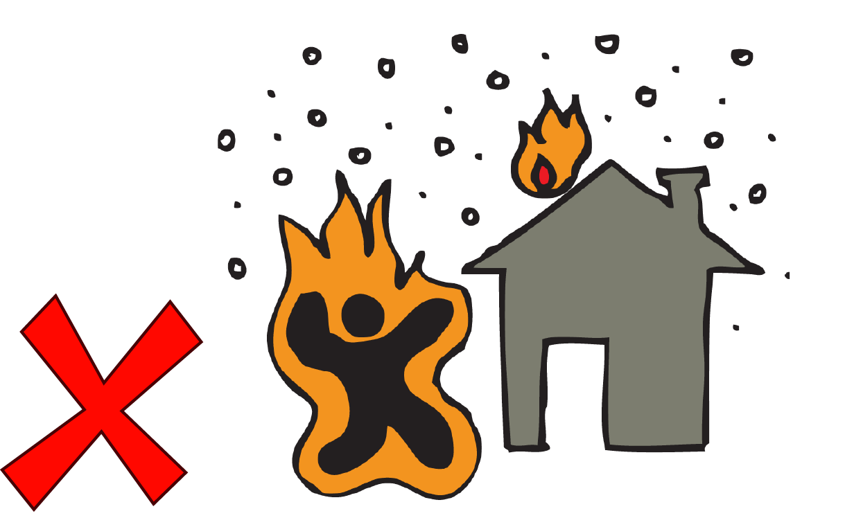
LA CENIZA NO CAUSA INCENDIOS. Existe la creencia popular de que la ceniza es un material incandescente y que al caer puede generar incendios, pero esto es completamente falso. Para cuando la ceniza llega al suelo ya se ha enfriado casi por completo.
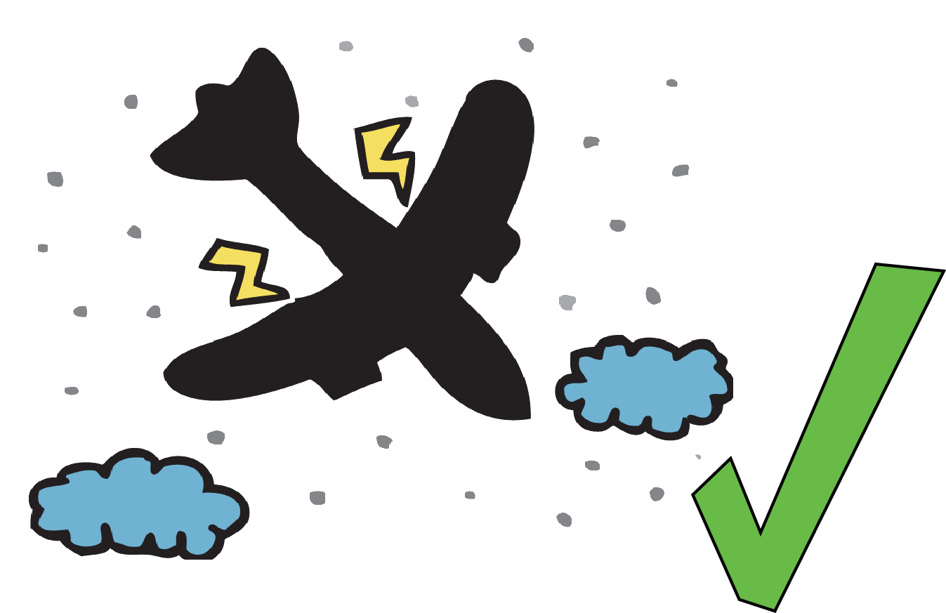
LA CENIZA SI AFECTA A LOS AVIONES. Cuando la ceniza entra en contacto con los motores/turbinas los daña por lo que puede causar grandes accidentes. Por esto en ocasiones se suspenden los vuelos, se cambian las rutas aéreas y se cierran aeropuertos.
LOS CENIZÓMETROS
El Instituto Geofísico ha colocado cenizómetros en los principales volcanes de Ecuador. Los cenizómetros son recipientes plásticos especialmente diseñados para recolectar cenizas que permiten a los investigadores saber donde cayó ceniza, en que cantidad y de qué características. Si ves un cenizómetro no lo destruyas, ¡¡CUÍDALO!! Está ahí para colaborar con el monitoreo volcánico y cuidar tu seguridad y la de todos los vecinos del volcán
Artículos científicos en revistas con revisión por pares IG-EPN (185 entre 1983 y 2017)
1983 (1)
- Hall ML (1983) Origin of Española Island and the age of terrestrial life on the Galápagos Islands. Science 221:545–547
1985 (2)
- Hall ML, Wood CA (1985) Volcano-tectonic segmentation of the northern Andes. Geology 13:203 . doi: 10.1130/0091-7613(1985)13<203:VSOTNA>2.0.CO;2
- McBirney AR, Cullen AB, Geist D, Vicenzi EP, Duncan RA, Hall ML, Estrella M (1985) The Galapagos volcano Alcedo: A unique ocean caldera. Journal of Volcanology and Geothermal Research 26:173–177 . doi: 10.1016/0377-0273(85)90052-6
1990 (1)
- Hall ML (1990) Chronology of the principal scientific and governmental actions leading up to the November 13, 1985 eruption of Nevado del Ruiz, Colombia. Journal of Volcanology and Geothermal Research 42:101–115
1995 (3)
- Chatelain J-L, Guillier B, Souris M, Duperier E, Yepes H (1995) Evaluating natural hazards using GIS: the case of seismic hazards in Quito, Ecuador. Mappemonde 95:17–22
- Ego F, Sebrier M, Yepes H (1995) Is the Cauca-Patia and Romeral fault system left or right lateral? Geophysical Research Letters 22:33–36
- Robin C, Monzier M, Hall M, Eissen J-P (1995) Mojanda volcano (Ecuador): two contemporaneous volcanoes with distinct eruptive dynamics, development and geochemical characteristics) (French with abridged English. Comptes Rendus - Academie des Sciences, Serie II: Sciences de la Terre et des Planetes 321:1111–1118
1996 (3)
- Ego F, Sébrier M, Lavenu A, Yepes H, Egues A (1996) Quaternary state of stress in the Northern Andes and the restraining bend model for the Ecuadorian Andes. Tectonophysics 259:101–116 . doi: 10.1016/0040-1951(95)00075-5
- Prévôt R, Châtelain J-L, Guillier B, Yepes H (1996) Mapping of the P-wave velocity structure beneath the ecuadorian andes: Evidence for continuity of the central Andes. Comptes Rendus de l’Academie de Sciences - Serie IIa: Sciences de la Terre et des Planetes 323:833–840
- Yepes H, Chatelain J-L, Guillier B, Alvarado A, Egred J, Ruiz M, Segovia M (1996) The Mw 6.8 Macas Earthquake in the Sub-Andean Zone of Ecuador, October 3, 1995. Seismological Research Letters 67:27–32 . doi: 10.1785/gssrl.67.6.27
1997 (5)
- Clapperton CM, Hall M, Mothes P, Hole MJ, Still JW, Helmens KF, Kuhry P, Gemmell AMD (1997) A Younger Dryas Icecap in the Equatorial Andes. Quaternary Research 47:13–28 . doi: 10.1006/qres.1996.1861
- Hibsch C, Alvarado A, Yepes H, Perez VH, Sébrier M (1997) Holocene liquefaction and soft-sediment deformation in Quito (Ecuador): A paleoseismic history recorded in lacustrine sediments. Journal of Geodynamics 24:259–280 . doi: 10.1016/S0264-3707(97)00010-0
- Monzier M, Robin C, Hall ML, Cotten J, Mothes P, Eissen J-P, Samaniego P (1997) Adakites from Ecuador: preliminary data. Comptes Rendus - Academie des Sciences, Serie II: Sciences de la Terre et des Planetes 324:545–552
- Robin C, Hall M, Jimenez M, Monzier M, Escobar P (1997) Mojanda volcanic complex (Ecuador): development of two adjacent contemporaneous volcanoes with contrasting eruptive styles and magmatic suites. Journal of South American Earth Sciences 10:345–359 . doi: 10.1016/S0895-9811(97)00030-8
- Villacís C, Tucker B, Yepes H, Kaneko F, Chatelain JL (1997) Use of seismic microzoning for risk management in Quito, Ecuador. Engineering Geology 46:63–70
1998 (5)
- Barragan R, Geist D, Hall M, Larson P, Kurz M (1998) Subduction controls on the compositions of lavas from the Ecuadorian Andes. Earth and Planetary Science Letters 154:153–166 . doi: 10.1016/S0012-821X(97)00141-6
- Guéguen P, Chatelain J-L, Guillier B, Yepes H, Egred J (1998) Site effect and damage distribution in Pujili (Ecuador) after the 28 March 1996 earthquake. Soil Dynamics and Earthquake Engineering 17:329–334 . doi: 10.1016/S0267-7261(98)00019-0
- Mothes PA, Hall ML, Janda RJ (1998) The enormous Chillos Valley Lahar: an ash-flow-generated debris flow from Cotopaxi Volcano, Ecuador. Bulletin of Volcanology 59:233–244 . doi: 10.1007/s004450050188
- Ruiz M, Guillier B, Chatelain J-L, Yepes H, Hall M, Ramon P (1998) Possible causes for the seismic activity observed in Cotopaxi volcano, Ecuador. Geophysical Research Letters 25:2305–2308
- Samaniego P, Monzier M, Robin C, Hall ML (1998) Late Holocene eruptive activity at Nevado Cayambe Volcano, Ecuador. Bulletin of Volcanology 59:451–459 . doi: 10.1007/s004450050203
1999 (5)
- Alvarado G, Acevedeo AP, Monsalve ML, Espíndola JM, Gómez D, Hall M, Naranjo JA, Pulgarín B, Raigosa J, Sigarán C, Van der Laat R (1999) Development of Volcanology in Latin Americ during the last quarter of the 20th Century. Revista Geofisica 51:185–241
- Bourdon E, Eissen J-P, Cotten J, Monzier M, Robin C, Hall ML (1999) Les laves calco-alcalines et à caractère adakitique du volcan Antisana (Equateur): hypothèse pétrogénétique. Comptes Rendus de l’Académie des Sciences - Series IIA - Earth and Planetary Science 328:443–449 . doi: 10.1016/S1251-8050(99)80144-X
- Chatelain J-L, Tucker B, Guillier B, Kaneko F, Yepes H, Fernandez J, Valverde J, Hoefer G, Souris M, Dupérier E, Yamada T, Bustamante G, Villacis C (1999) Earthquake risk management pilot project in Quito, Ecuador. GeoJournal 49:185–196 . doi: 10.1023/A:1007079403225
- Hall ML, Robin C, Beate B, Mothes P, Monzier M (1999) Tungurahua Volcano, Ecuador: structure, eruptive history and hazards. Journal of Volcanology and Geothermal Research 91:1–21 . doi: 10.1016/S0377-0273(99)00047-5
- Monzier M, Robin C, Samaniego P, Hall ML, Cotten J, Mothes P, Arnaud N (1999) Sangay volcano, Ecuador: structural development, present activity and petrology. Journal of Volcanology and Geothermal Research 90:49–79 . doi: 10.1016/S0377-0273(99)00021-9
2000 (1)
- Guéguen P, Chatelain J-L, Guillier B, Yepes H (2000) An indication of the soil topmost layer response in Quito (Ecuador) using noise H/V spectral ratio. Soil Dynamics and Earthquake Engineering 19:127–133 . doi: 10.1016/S0267-7261(99)00035-4
2001 (2)
- Guillier B, Chatelain J-L, Jaillard é., Yepes H, Poupinet G, Fels J-F (2001) Seismological evidence on the geometry of the Orogenic System in central-northern Ecuador (South America). Geophysical Research Letters 28:3749–3752 . doi: 10.1029/2001GL013257
- Mothes PA, Yepes H, Ruiz MC, Molina C, Ramon P, Hall ML (2001) Reactivación y Vigilancia Intensa del Volcán Tungurahua-Ecuador: Perspectivas y Objetivos. Cooperazione Internazionale
2002 (5)
- Bourdon E (2002a) Adakite-like Lavas from Antisana Volcano (Ecuador): Evidence for Slab Melt Metasomatism Beneath Andean Northern Volcanic Zone. Journal of Petrology 43:199–217 . doi: 10.1093/petrology/43.2.199
- Bourdon E (2002b) Slab melting and slab melt metasomatism in the Northern Andean Volcanic Zone : adakites and high-Mg andesites from Pichincha volcano (Ecuador). Bulletin de la Société Géologique de France 173:195–206 . doi: 10.2113/173.3.195
- Collot J-Y, Charvis P, Gutscher M-A, Operto S (2002) Exploring the Ecuador-Colombia Active Margin and Interplate Seismogenic Zone. Eos, Transactions American Geophysical Union 83:185
- Legrand D, Calahorrano A, Guillier B, Rivera L, Ruiz M, Villagómez D, Yepes H (2002) Stress tensor analysis of the 1998–1999 tectonic swarm of northern Quito related to the volcanic swarm of Guagua Pichincha volcano, Ecuador. Tectonophysics 344:15–36 . doi: 10.1016/S0040-1951(01)00273-6
- Samaniego P, Martin H, Robin C, Monzier M (2002) Transition from calc-alkalic to adakitic magmatism at Cayambe volcano, Ecuador: Insights into slab melts and mantle wedge interactions. Geology 30:967 . doi: 10.1130/0091-7613(2002)030<0967:TFCATA>2.0.CO;2
2003 (4)
- Aster R (2003) Very long period oscillations of Mount Erebus Volcano. Journal of Geophysical Research 108: . doi: 10.1029/2002JB002101
- Bourdon E, Eissen J-P, Gutscher M-A, Monzier M, Hall ML, Cotten J (2003) Magmatic response to early aseismic ridge subduction: the Ecuadorian margin case (South America). Earth and Planetary Science Letters 205:123–138 . doi: 10.1016/S0012-821X(02)01024-5
- Chouet B, Dawson P, Ohminato T, Martini M, Saccorotti G, Giudicepietro F, De Luca G, Milana G, Scarpa R (2003) Source mechanisms of explosions at Stromboli Volcano, Italy, determined from moment-tensor inversions of very-long-period data: SOURCE MECHANISMS OF EXPLOSION AT STROMBOLI. Journal of Geophysical Research: Solid Earth 108:ESE 7-1-ESE 7-25 . doi: 10.1029/2002JB001919
- Johnson JB, Aster RC, Ruiz MC, Malone SD, McChesney PJ, Lees JM, Kyle PR (2003) Interpretation and utility of infrasonic records from erupting volcanoes. Journal of Volcanology and Geothermal Research 121:15–63 . doi: 10.1016/S0377-0273(02)00409-2
2004 (7)
- Aster R, MacIntosh W, Kyle P, Esser R, Bartel B, Dunbar N, Johnson J, Karstens R, Kurnik C, McGowan M, McNamara S, Meertens C, Pauly B, Richmond M, Ruiz M (2004) Real-time data received from Mount Erebus Volcano, Antarctica. Eos, Transactions American Geophysical Union 85:97
- Bourdon E, Samaniego P, Monzier M, Robin C, Eissen J-P, Martin H (2004) Dubious case for slab melting in the Northern volcanic zone of the Andes: Comment and Reply: COMMENT. Geology 32:e46–e47 . doi: 10.1130/0091-7613-32.1.e46
- Graindorge D (2004) Deep structures of the Ecuador convergent margin and the Carnegie Ridge, possible consequence on great earthquakes recurrence interval. Geophysical Research Letters 31: . doi: 10.1029/2003GL018803
- Hall M, Ramón P, Mothes P, LePennec JL, García A, Samaniego P, Yepes H (2004) Volcanic eruptions with little warning: the case of Volcán Reventador’s Surprise November 3, 2002 Eruption, Ecuador. Revista geológica de Chile 31: . doi: 10.4067/S0716-02082004000200010
- Johnson JB (2004) Volcanic eruptions observed with infrasound. Geophysical Research Letters 31: . doi: 10.1029/2004GL020020
- Legrand D, Villagómez D, Yepes H, Calahorrano A (2004) Multifractal dimension and b value analysis of the 1998–1999 Quito swarm related to Guagua Pichincha volcano activity, Ecuador. J Geophys Res 109:B01307 . doi: 10.1029/2003JB002572
- Molina I, Kumagai H, Yepes H (2004) Resonances of a volcanic conduit triggered by repetitive injections of an ash-laden gas. Geophys Res Lett 31:L03603 . doi: 10.1029/2003GL018934
2005 (5)
- Collot J-Y, Migeon S, Spence G, Legonidec Y, Marcaillou B, Schneider J-L, Michaud F, Alvarado A, Lebrun J-F, Sosson M, Pazmino A (2005) Seafloor margin map helps in understanding subduction earthquakes. Eos 86:
- Johnson JB (2005) Poor scaling between elastic energy release and eruption intensity at Tungurahua Volcano, Ecuador. Geophysical Research Letters 32: . doi: 10.1029/2005GL022847
- Molina I, Kumagai H, Le Pennec J-L, Hall M (2005) Three-dimensional P-wave velocity structure of Tungurahua Volcano, Ecuador. Journal of Volcanology and Geothermal Research 147:144–156 . doi: 10.1016/j.jvolgeores.2005.03.011
- Samaniego P, Martin H, Monzier M, Robin C, Fornari M, Eissen J-P, Cotten J (2005) Temporal Evolution of Magmatism in the Northern Volcanic Zone of the Andes: The Geology and Petrology of Cayambe Volcanic Complex (Ecuador). J Petrology 46:2225–2252 . doi: 10.1093/petrology/egi053
- Segovia M (2005) 14 Years of instrumental seismicity in ecuador: What have we seen and learned? Bulletin of the International Institute of Seismology and Earthquake Engineering 39:1–11
2006 (5)
- Bryant JA, Yogodzinski GM, Hall ML, Lewicki JL, Bailey DG (2006) Geochemical Constraints on the Origin of Volcanic Rocks from the Andean Northern Volcanic Zone, Ecuador. J Petrology 47:1147–1175 . doi: 10.1093/petrology/egl006
- Johnson JB, Lees JM, Yepes H (2006) Volcanic eruptions, lightning, and a waterfall: Differentiating the menagerie of infrasound in the Ecuadorian jungle. Geophysical Research Letters 33: . doi: 10.1029/2005GL025515
- Opdyke ND, Hall M, Mejia V, Huang K, Foster DA (2006) Time-averaged field at the equator: Results from Ecuador. Geochemistry, Geophysics, Geosystems 7: . doi: 10.1029/2005GC001221
- Ruiz MC, Lees JM, Johnson JB (2006) Source constraints of Tungurahua volcano explosion events. Bulletin of Volcanology 68:480–490 . doi: 10.1007/s00445-005-0023-8
- Werner-Allen G, Lorincz K, Welsh M, Marcillo O, Johnson J, Ruiz M, Lees J (2006) Deploying a wireless sensor network on an active volcano. IEEE Internet Computing 10:18–25 . doi: 10.1109/MIC.2006.26
2007 (4)
- Garcia-Aristizabal A, Kumagai H, Samaniego P, Mothes P, Yepes H, Monzier M (2007) Seismic, petrologic, and geodetic analyses of the 1999 dome-forming eruption of Guagua Pichincha volcano, Ecuador. Journal of Volcanology and Geothermal Research 161:333–351 . doi: 10.1016/j.jvolgeores.2006.12.007
- Hidalgo S, Monzier M, Martin H, Chazot G, Eissen J-P, Cotten J (2007) Adakitic magmas in the Ecuadorian Volcanic Front: Petrogenesis of the Iliniza Volcanic Complex (Ecuador). Journal of Volcanology and Geothermal Research 159:366–392 . doi: 10.1016/j.jvolgeores.2006.07.007
- Kumagai H, Yepes H, Vaca M, Caceres V, Nagai T, Yokoe K, Imai T, Miyakawa K, Yamashina T, Arrais S, Vasconez F, Pinajota E, Cisneros C, Ramos C, Paredes M, Gomezjurado L, Garcia-Aristizabal A, Molina I, Ramon P, Segovia M, Palacios P, Troncoso L, Alvarado A, Aguilar J, Pozo J, Enriquez W, Mothes P, Hall M, Inoue I, Nakano M, Inoue H (2007) Enhancing volcano-monitoring capabilities in Ecuador. Eos 88:245–246
- Naumova EN, Yepes H, Griffiths JK, Sempértegui F, Khurana G, Jagai JS, Játiva E, Estrella B (2007) Emergency room visits for respiratory conditions in children increased after Guagua Pichincha volcanic eruptions in April 2000 in Quito, Ecuador Observational Study: Time Series Analysis. Environmental Health 6:21 . doi: 10.1186/1476-069X-6-21
2008 (21)
- Arellano SR, Hall M, Samaniego P, Le Pennec J-L, Ruiz A, Molina I, Yepes H (2008) Degassing patterns of Tungurahua volcano (Ecuador) during the 1999–2006 eruptive period, inferred from remote spectroscopic measurements of SO2 emissions. Journal of Volcanology and Geothermal Research 176:151–162 . doi: 10.1016/j.jvolgeores.2008.07.007
- Barba D, Robin C, Samaniego P, Eissen J-P (2008) Holocene recurrent explosive activity at Chimborazo volcano (Ecuador). Journal of Volcanology and Geothermal Research 176:27–35 . doi: 10.1016/j.jvolgeores.2008.05.004
- Bernard B, van Wyk de Vries B, Barba D, Leyrit H, Robin C, Alcaraz S, Samaniego P (2008) The Chimborazo sector collapse and debris avalanche: deposit characteristics as evidence of emplacement mechanisms. Journal of Volcanology and Geophysical Research 176:36–43
- Carn SA, Krueger AJ, Arellano S, Krotkov NA, Yang K (2008) Daily monitoring of Ecuadorian volcanic degassing from space. Journal of Volcanology and Geothermal Research 176:141–150 . doi: 10.1016/j.jvolgeores.2008.01.029
- Garcés M, Fee D, Steffke A, McCormack D, Servranckx R, Bass H, Hetzer C, Hedlin M, Matoza R, Yepes H, Ramon P (2008) Capturing the Acoustic Fingerprint of Stratospheric Ash Injection. Eos, Transactions American Geophysical Union 89:377–378
- Geist DJ, Harpp KS, Naumann TR, Poland M, Chadwick WW, Hall M, Rader E (2008) The 2005 eruption of Sierra Negra volcano, Galápagos, Ecuador. Bulletin of Volcanology 70:655–673 . doi: 10.1007/s00445-007-0160-3
- Hall M, Mothes P (2008a) The rhyolitic–andesitic eruptive history of Cotopaxi volcano, Ecuador. Bulletin of Volcanology 70:675–702 . doi: 10.1007/s00445-007-0161-2
- Hall ML, Mothes PA (2008b) Quilotoa volcano — Ecuador: An overview of young dacitic volcanism in a lake-filled caldera. Journal of Volcanology and Geothermal Research 176:44–55 . doi: 10.1016/j.jvolgeores.2008.01.025
- Hall ML, Mothes PA (2008c) Volcanic impediments in the progressive development of pre-Columbian civilizations in the Ecuadorian Andes. Journal of Volcanology and Geothermal Research 176:344–355 . doi: 10.1016/j.jvolgeores.2008.01.039
- Hall ML, Samaniego P, Le Pennec JL, Johnson JB (2008) Ecuadorian Andes volcanism: A review of Late Pliocene to present activity. Journal of Volcanology and Geothermal Research 176:1–6 . doi: 10.1016/j.jvolgeores.2008.06.012
- Hidalgo S, Monzier M, Almeida E, Chazot G, Eissen J-P, van der Plicht J, Hall ML (2008) Late Pleistocene and Holocene activity of the Atacazo–Ninahuilca Volcanic Complex (Ecuador). Journal of Volcanology and Geothermal Research 176:16–26 . doi: 10.1016/j.jvolgeores.2008.05.017
- Iguchi M, Yakiwara H, Tameguri T, Hendrasto M, Hirabayashi J (2008) Mechanism of explosive eruption revealed by geophysical observations at the Sakurajima, Suwanosejima and Semeru volcanoes. Journal of Volcanology and Geothermal Research 178:1–9 . doi: 10.1016/j.jvolgeores.2007.10.010
- Johnson J, Samaniego P, Hall ML (P. ., Le Pennec J-L (2008) Foreword. Journal of Volcanology and Geothermal Research 176: . doi: 10.1016/j.jvolgeores.2008.08.005
- Le Pennec J-L, Jaya D, Samaniego P, Ramón P, Moreno Yánez S, Egred J, van der Plicht J (2008) The AD 1300–1700 eruptive periods at Tungurahua volcano, Ecuador, revealed by historical narratives, stratigraphy and radiocarbon dating. Journal of Volcanology and Geothermal Research 176:70–81 . doi: 10.1016/j.jvolgeores.2008.05.019
- Lees JM, Johnson JB, Ruiz M, Troncoso L, Welsh M (2008) Reventador Volcano 2005: Eruptive activity inferred from seismo-acoustic observation. Journal of Volcanology and Geothermal Research 176:179–190 . doi: 10.1016/j.jvolgeores.2007.10.006
- Lees JM, Ruiz M (2008) Non-linear explosion tremor at Sangay, Volcano, Ecuador. Journal of Volcanology and Geothermal Research 176:170–178 . doi: 10.1016/j.jvolgeores.2007.08.012
- Molina I, Kumagai H, García-Aristizábal A, Nakano M, Mothes P (2008) Source process of very-long-period events accompanying long-period signals at Cotopaxi Volcano, Ecuador. Journal of Volcanology and Geothermal Research 176:119–133 . doi: 10.1016/j.jvolgeores.2007.07.019
- Mothes PA, Hall ML (2008) The plinian fallout associated with Quilotoa’s 800 yr BP eruption, Ecuadorian Andes. Journal of Volcanology and Geothermal Research 176:56–69 . doi: 10.1016/j.jvolgeores.2008.05.018
- Robin C, Samaniego P, Le Pennec J-L, Mothes P, van der Plicht J (2008) Late Holocene phases of dome growth and Plinian activity at Guagua Pichincha volcano (Ecuador). Journal of Volcanology and Geothermal Research 176:7–15 . doi: 10.1016/j.jvolgeores.2007.10.008
- Samaniego P, Eissen J-P, Le Pennec J-L, Robin C, Hall ML, Mothes P, Chavrit D, Cotten J (2008) Pre-eruptive physical conditions of El Reventador volcano (Ecuador) inferred from the petrology of the 2002 and 2004–05 eruptions. Journal of Volcanology and Geothermal Research 176:82–93 . doi: 10.1016/j.jvolgeores.2008.03.004
- Vigouroux N, Williams-Jones G, Chadwick W, Geist D, Ruiz A, Johnson D (2008) 4D gravity changes associated with the 2005 eruption of Sierra Negra volcano, Galápagos. Geophysics 73:WA29-WA35 . doi: 10.1190/1.2987399
2009 (8)
- Bernard B, van Wyk de Vries B, Leyrit H (2009) Distinguishing volcanic debris avalanche deposits from their reworked products: the Perrier sequence (French Massif Central). Bulletin of Volcanology 71:1041–1056 . doi: 10.1007/s00445-009-0285-7
- Collot J-Y, Michaud F, Alvarado A, Marcaillou B, Sosson M, Ratzov G, Migeon S, Calahorrano A (2009) Visión general de la morfología submarina del margen convergente de Ecuador-Sur de Colombia: implicaciones sobre la transferencia de masa y la edad de la subducción de la Cordillera de Carnegie. GEOLOGÍA Y GEOFÍSICA MARINA Y TERRESTRE DEL ECUADOR DESDE LA COSTA CONTINENTAL HASTA LAS ISLAS GALÁPAGOS 47–74
- Johnson J, Ruiz M (2009) Field Geophysics Class at Volcán Tungurahua, Ecuador. Eos, Transactions American Geophysical Union 90:442 . doi: 10.1029/2009EO470002
- Kelfoun K, Samaniego P, Palacios P, Barba D (2009) Testing the suitability of frictional behaviour for pyroclastic flow simulation by comparison with a well-constrained eruption at Tungurahua volcano (Ecuador). Bulletin of Volcanology 71:1057–1075 . doi: 10.1007/s00445-009-0286-6
- Kumagai H, Palacios P, Maeda T, Castillo DB, Nakano M (2009) Seismic tracking of lahars using tremor signals. Journal of Volcanology and Geothermal Research 183:112–121 . doi: 10.1016/j.jvolgeores.2009.03.010
- Matoza RS, Fee D, Garcés MA, Seiner JM, Ramón PA, Hedlin M a. H (2009) Infrasonic jet noise from volcanic eruptions. Geophys Res Lett 36:L08303 . doi: 10.1029/2008GL036486
- Robin C, Eissen J-P, Samaniego P, Martin H, Hall M, Cotten J (2009) Evolution of the late Pleistocene Mojanda–Fuya Fuya volcanic complex (Ecuador), by progressive adakitic involvement in mantle magma sources. Bulletin of Volcanology 71:233–258 . doi: 10.1007/s00445-008-0219-9
- Vaca S, Regnier M, Bethoux N, Alvarez V, Bernard P (2009) Sismicidad de la región de Manta: Enjambre sísmico de Manta-2005. 151–166
2010 (8)
- Andrade SD, van Wyk de Vries B (2010) Structural analysis of the early stages of catastrophic stratovolcano flank-collapse using analogue models. Bulletin of Volcanology 72:771–789 . doi: 10.1007/s00445-010-0363-x
- Beauval C, Yepes H, Bakun WH, Egred J, Alvarado A, Singaucho J (2010) Locations and magnitudes of historical earthquakes in the Sierra of Ecuador (1587-1996). Geophysical Journal International 181:1613–1633 . doi: 10.1111/j.1365-246X.2010.04569.x
- Biggs J, Mothes P, Ruiz M, Amelung F, Dixon TH, Baker S, Hong S-H (2010) Stratovolcano growth by co-eruptive intrusion: The 2008 eruption of Tungurahua Ecuador: INSAR OF 2008 ERUPTION OF TUNGURAHUA. Geophysical Research Letters 37:n/a-n/a . doi: 10.1029/2010GL044942
- Galle B, Johansson M, Rivera C, Zhang Y, Kihlman M, Kern C, Lehmann T, Platt U, Arellano S, Hidalgo S (2010) Network for Observation of Volcanic and Atmospheric Change (NOVAC)—A global network for volcanic gas monitoring: Network layout and instrument description. Journal of Geophysical Research 115: . doi: 10.1029/2009JD011823
- Inguaggiato S, Hidalgo S, Beate B, Bourquin J (2010) Geochemical and isotopic characterization of volcanic and geothermal fluids discharged from the Ecuadorian volcanic arc: Geochemistry of Ecuadorian volcanic fluids. Geofluids 10:525–541 . doi: 10.1111/j.1468-8123.2010.00315.x
- Kim S-W, Wdowinski S, Dixon TH, Amelung F, Kim JW, Won J-S (2010) Measurements and predictions of subsidence induced by soil consolidation using persistent scatterer InSAR and a hyperbolic model: SUBSIDENCE FROM PSI AND HYPERBOLIC MODEL. Geophysical Research Letters 37:n/a-n/a . doi: 10.1029/2009GL041644
- Kumagai H, Nakano M, Maeda T, Yepes H, Palacios P, Ruiz M, Arrais S, Vaca M, Molina I, Yamashima T (2010) Broadband seismic monitoring of active volcanoes using deterministic and stochastic approaches. Journal of Geophysical Research: Solid Earth 115: . doi: 10.1029/2009JB006889
- Robin C, Samaniego P, Le Pennec J-L, Fornari M, Mothes P, van der Plicht J (2010) New radiometric and petrological constraints on the evolution of the Pichincha volcanic complex (Ecuador). Bulletin of Volcanology 72:1109–1129 . doi: 10.1007/s00445-010-0389-0
2011 (11)
- Arnaud-Haond S, Arrieta JM, Duarte CM (2011) Marine Biodiversity and Gene Patents. Science 331:1521–1522 . doi: 10.1126/science.1200783
- Bethoux N, Segovia M, Alvarez V, Collot J-Y, Charvis P, Gailler A, Monfret T (2011) Seismological study of the central Ecuadorian margin: Evidence of upper plate deformation. Journal of South American Earth Sciences 31:139–152 . doi: 10.1016/j.jsames.2010.08.001
- Cárdenas ML, Gosling WD, Sherlock SC, Poole I, Pennington RT, Mothes P (2011a) Response to comment on “The response of vegetation on the Andean flank in Western Amazonia to Pleistocene climate change”. Science 333: . doi: 10.1126/science.1207888
- Cárdenas ML, Gosling WD, Sherlock SC, Poole I, Pennington RT, Mothes P (2011b) The response of vegetation on the Andean Flank in Western Amazonia to Pleistocene climate change. Science 331:1055–1058 . doi: 10.1126/science.1197947
- Chadwick WW, Jónsson S, Geist DJ, Poland M, Johnson DJ, Batt S, Harpp KS, Ruiz A (2011) The May 2005 eruption of Fernandina volcano, Galápagos: The first circumferential dike intrusion observed by GPS and InSAR. Bulletin of Volcanology 73:679–697 . doi: 10.1007/s00445-010-0433-0
- Garrison JM, Davidson JP, Hall M, Mothes P (2011) Geochemistry and Petrology of the Most Recent Deposits from Cotopaxi Volcano, Northern Volcanic Zone, Ecuador. Journal of Petrology 52:1641–1678 . doi: 10.1093/petrology/egr023
- Knight CLF, Cuéllar AM, Glascock MD, Hall ML, Mothes PA (2011) Obsidian source characterization in the Cordillera Real and eastern piedmont of the north Ecuadorian Andes. Journal of Archaeological Science 38:1069–1079 . doi: 10.1016/j.jas.2010.12.002
- Kumagai H, Placios P, Ruiz M, Yepes H, Kozono T (2011) Ascending seismic source during an explosive eruption at Tungurahua volcano, Ecuador. Geophysical Research Letters 38: . doi: 10.1029/2010GL045944
- Le Pennec JL, Ruiz AG, Eissen JP, Hall ML, Fornari M (2011) Identifying potentially active volcanoes in the Andes: Radiometric evidence for late Pleistocene-early Holocene eruptions at Volcán Imbabura, Ecuador. Journal of Volcanology and Geothermal Research 206:121–135 . doi: 10.1016/j.jvolgeores.2011.06.002
- Manchuel K, Régnier M, Béthoux N, Font Y, Sallarès V, Díaz J, Yepes H (2011) New insights on the interseismic active deformation along the North Ecuadorian-South Colombian (NESC) margin: SEISMOTECTONIC STUDY OF THE NESC MARGIN. Tectonics 30:n/a-n/a . doi: 10.1029/2010TC002757
- Samaniego P, Le Pennec J-L, Robin C, Hidalgo S (2011) Petrological analysis of the pre-eruptive magmatic process prior to the 2006 explosive eruptions at Tungurahua volcano (Ecuador). Journal of Volcanology and Geothermal Research 199:69–84 . doi: 10.1016/j.jvolgeores.2010.10.010
2012 (11)
- Colman A, Sinton JM, White SM, McClinton JT, Bowles JA, Rubin KH, Behn MD, Cushman B, Eason DE, Gregg TKP, Grönvold K, Hidalgo S, Howell J, Neill O, Russo C (2012) Effects of variable magma supply on mid-ocean ridge eruptions: Constraints from mapped lava flow fields along the Galápagos Spreading Center: GSC VOLCANIC ERUPTIONS. Geochemistry, Geophysics, Geosystems 13:n/a-n/a . doi: 10.1029/2012GC004163
- Eychenne J, Le Pennec J-L, Troncoso L, Gouhier M, Nedelec J-M (2012) Causes and consequences of bimodal grain-size distribution of tephra fall deposited during the August 2006 Tungurahua eruption (Ecuador). Bulletin of Volcanology 74:187–205 . doi: 10.1007/s00445-011-0517-5
- Hidalgo S, Gerbe MC, Martin H, Samaniego P, Bourdon E (2012) Role of crustal and slab components in the Northern Volcanic Zone of the Andes (Ecuador) constrained by Sr–Nd–O isotopes. Lithos 132–133:180–192 . doi: 10.1016/j.lithos.2011.11.019
- Kim K, Lees JM, Ruiz M (2012) Acoustic multipole source model for volcanic explosions and inversion for source parameters. Geophysical Journal International 191:1192–1204 . doi: 10.1111/j.1365-246X.2012.05696.x
- Le Pennec J-L, Ruiz GA, Ramón P, Palacios E, Mothes P, Yepes H (2012) Impact of tephra falls on Andean communities: The influences of eruption size and weather conditions during the 1999–2001 activity of Tungurahua volcano, Ecuador. Journal of Volcanology and Geothermal Research 217–218:91–103 . doi: 10.1016/j.jvolgeores.2011.06.011
- Samaniego P, Barba D, Robin C, Fornari M, Bernard B (2012) Eruptive history of Chimborazo volcano (Ecuador): A large, ice-capped and hazardous compound volcano in the Northern Andes. Journal of Volcanology and Geothermal Research 221–222:33–51 . doi: 10.1016/j.jvolgeores.2012.01.014
- Wright HMN, Cashman KV, Mothes PA, Hall ML, Ruiz AG, Le Pennec J-L (2012) Estimating rates of decompression from textures of erupted ash particles produced by 1999-2006 eruptions of Tungurahua volcano, Ecuador. Geology 40:619–622 . doi: 10.1130/G32948.1
2013 (12)
- Beauval C, Yepes H, Palacios P, Segovia M, Alvarado A, Font Y, Aguilar J, Troncoso L, Vaca S (2013) An earthquake catalog for seismic hazard assessment in Ecuador. Bulletin of the Seismological Society of America 103:773–786 . doi: 10.1785/0120120270
- Bernard B (2013) Homemade ashmeter: a low-cost, high-efficiency solution to improve tephra field-data collection for contemporary explosive eruptions. Journal of Applied Volcanology 2:1 . doi: 10.1186/2191-5040-2-1
- Bernard B, Bustillos J, Wade B, Hidalgo S (2013) Influence of the wind direction variability on the quantification of tephra fallouts: December 2012 and March 2013 Tungurahua eruptions. Avances en Ciencias e Ingenierías 5:A14–A21
- Douillet GA, Pacheco DA, Kueppers U, Letort J, Tsang-Hin-Sun È, Bustillos J, Hall M, Ramón P, Dingwell DB (2013a) Dune bedforms produced by dilute pyroclastic density currents from the August 2006 eruption of Tungurahua volcano, Ecuador. Bull Volcanol 75:1–20 . doi: 10.1007/s00445-013-0762-x
- Douillet GA, Tsang-Hin-Sun È, Kueppers U, Letort J, Pacheco DA, Goldstein F, Von Aulock F, Lavallée Y, Hanson JB, Bustillos J, Robin C, Ramón P, Hall M, Dingwell DB (2013b) Sedimentology and geomorphology of the deposits from the August 2006 pyroclastic density currents at Tungurahua volcano, Ecuador. Bulletin of Volcanology 75:1–21 . doi: 10.1007/s00445-013-0765-7
- Eychenne J, Le Pennec J-L, Ramón P, Yepes H (2013) Dynamics of explosive paroxysms at open-vent andesitic systems: High-resolution mass distribution analyses of the 2006 Tungurahua fall deposit (Ecuador). Earth and Planetary Science Letters 361:343–355 . doi: 10.1016/j.epsl.2012.11.002
- Font Y, Segovia M, Vaca S, Theunissen T (2013) Seismicity patterns along the ecuadorian subduction zone: New constraints from earthquake location in a 3-D a priori velocity model. Geophysical Journal International 193:263–286 . doi: 10.1093/gji/ggs083
- Hall ML, Steele AL, Mothes PA, Ruiz MC (2013) Pyroclastic density currents (PDC) of the 16–17 August 2006 eruptions of Tungurahua volcano, Ecuador: Geophysical registry and characteristics. Journal of Volcanology and Geothermal Research 265:78–93 . doi: 10.1016/j.jvolgeores.2013.08.011
- Kumagai H, Lacson Jr. R, Maeda Y, Figueroa II MS, Yamashina T, Ruiz M, Palacios P, Ortiz H, Yepes H (2013) Source amplitudes of volcano-seismic signals determined by the amplitude source location method as a quantitative measure of event size. Journal of Volcanology and Geothermal Research 257:57–71 . doi: 10.1016/j.jvolgeores.2013.03.002
- Le Pennec J-L, de Saulieu G, Samaniego P, Jaya D, Gailler L (2013) A devastating Plinian eruption at Tungurahua volcano reveals formative occupation at ~1100 cal BC in central Ecuador. Radiocarbon 55:1199–1214 . doi: 10.2458/azu_js_rc.55.16225
- Ledru M-P, Jomelli V, Samaniego P, Vuille M, Hidalgo S, Herrera M, Ceron C (2013) The Medieval Climate Anomaly and the Little Ice Age in the eastern Ecuadorian Andes. Climate of the Past 9:307–321 . doi: 10.5194/cp-9-307-2013
- Vallée M, Nocquet J-M, Battaglia J, Font Y, Segovia M, Régnier M, Mothes P, Jarrin P, Cisneros D, Vaca S, Yepes H, Martin X, Béthoux N, Chlieh M (2013) Intense interface seismicity triggered by a shallow slow slip event in the Central Ecuador subduction zone: SLOW SLIP AND MICROSEISMICITY. Journal of Geophysical Research: Solid Earth 118:2965–2981 . doi: 10.1002/jgrb.50216
2014 (11)
- Alvarado A, Audin L, Nocquet JM, Lagreulet S, Segovia M, Font Y, Lamarque G, Yepes H, Mothes P, Rolandone F, Jarrín P, Quidelleur X (2014) Active tectonics in Quito, Ecuador, assessed by geomorphological studies, GPS data, and crustal seismicity. Tectonics 33:67–83 . doi: 10.1002/2012TC003224
- Beauval C, Yepes H, Audin L, Alvarado A, Nocquet J-M, Monelli D, Danciu L (2014) Probabilistic Seismic-Hazard Assessment in Quito, Estimates and Uncertainties. Seismological Research Letters 85:1316–1327 . doi: 10.1785/0220140036
- Bernard B, Hidalgo S, Robin C, Beate B, Quijozaca J (2014) The 3640–3510 BC rhyodacite eruption of Chachimbiro compound volcano, Ecuador: a violent directed blast produced by a satellite dome. Bull Volcanol 76:1–20 . doi: 10.1007/s00445-014-0849-z
- Cárdenas ML, Gosling WD, Pennington RT, Poole I, Sherlock SC, Mothes P (2014) Forests of the tropical eastern Andean flank during the middle Pleistocene. Palaeogeography, Palaeoclimatology, Palaeoecology 393:76–89 . doi: 10.1016/j.palaeo.2013.10.009
- Champenois J, Pinel V, Baize S, Audin L, Jomard H, Hooper A, Alvarado A, Yepes H (2014) Large-scale inflation of Tungurahua volcano (Ecuador) revealed by Persistent Scatterers SAR interferometry. Geophysical Research Letters 41:5821–5828 . doi: 10.1002/2014GL060956
- Chlieh M, Mothes PA, Nocquet J-M, Jarrin P, Charvis P, Cisneros D, Font Y, Collot J-Y, Villegas-Lanza J-C, Rolandone F, Vallée M, Regnier M, Segovia M, Martin X, Yepes H (2014) Distribution of discrete seismic asperities and aseismic slip along the Ecuadorian megathrust. Earth and Planetary Science Letters 400:292–301 . doi: 10.1016/j.epsl.2014.05.027
- Kim K, Lees JM, Ruiz MC (2014) Source mechanism of Vulcanian eruption at Tungurahua Volcano, Ecuador, derived fromseismic moment tensor inversions. Journal of Geophysical Research: Solid Earth 119:1145–1164 . doi: 10.1002/2013JB010590
- McCormick BT, Herzog M, Yang J, Edmonds M, Mather TA, Carn SA, Hidalgo S, Langmann B (2014) A comparison of satellite- and ground-based measurements of SO2 emissions from Tungurahua volcano, Ecuador. Journal of Geophysical Research: Atmospheres 119:4264–4285 . doi: 10.1002/2013JD019771
- Nocquet J-M, Villegas-Lanza JC, Chlieh M, Mothes PA, Rolandone F, Jarrin P, Cisneros D, Alvarado A, Audin L, Bondoux F, Martin X, Font Y, Régnier M, Vallée M, Tran T, Beauval C, Maguiña Mendoza JM, Martinez W, Tavera H, Yepes H (2014) Motion of continental slivers and creeping subduction in the northern Andes. Nature Geoscience 7:287–291 . doi: 10.1038/ngeo2099
- Stone J, Barclay J, Simmons P, Cole PD, Loughlin SC, Ramón P, Mothes P (2014) Risk reduction through community-based monitoring: the vigías of Tungurahua, Ecuador. Journal of Applied Volcanology 3:11 . doi: 10.1186/s13617-014-0011-9
- Tepp G, Ebinger CJ, Ruiz M, Belachew M (2014) Imaging rapidly deforming ocean island volcanoes in the western Galápagos archipelago, Ecuador. Journal of Geophysical Research: Solid Earth 119:442–463 . doi: 10.1002/2013JB010227
2015 (11)
- Baize S, Audin L, Winter T, Alvarado A, Pilatasig Moreno L, Taipe M, Reyes P, Kauffmann P, Yepes H (2015) Paleoseismology and tectonic geomorphology of the Pallatanga fault (Central Ecuador), a major structure of the South-American crust. Geomorphology 237:14–28 . doi: 10.1016/j.geomorph.2014.02.030
- Bernard B, Kueppers U, Ortiz H (2015) Revisiting the statistical analysis of pyroclast density and porosity data. Solid Earth 6:869–879 . doi: 10.5194/se-6-869-2015
- Hall ML, Steele AL, Bernard B, Mothes PA, Vallejo SX, Douillet GA, Ramón PA, Aguaiza SX, Ruiz MC (2015) Sequential plug formation, disintegration by Vulcanian explosions, and the generation of granular Pyroclastic Density Currents at Tungurahua volcano (2013–2014), Ecuador. Journal of Volcanology and Geothermal Research 306:90–103 . doi: 10.1016/j.jvolgeores.2015.09.009
- Hickey J, Gottsmann J, Mothes P (2015) Estimating volcanic deformation source parameters with a finite element inversion: The 2001-2002 unrest at Cotopaxi volcano, Ecuador. Journal of Geophysical Research: Solid Earth 120:1473–1486 . doi: 10.1002/2014JB011731
- Hidalgo S, Battaglia J, Arellano S, Steele A, Bernard B, Bourquin J, Galle B, Arrais S, Vásconez F (2015) SO2 degassing at Tungurahua volcano (Ecuador) between 2007 and 2013: Transition from continuous to episodic activity. Journal of Volcanology and Geothermal Research 298:1–14 . doi: 10.1016/j.jvolgeores.2015.03.022
- Jones R, Manville V, Andrade D (2015) Probabilistic analysis of rain-triggered lahar initiation at Tungurahua volcano. Bulletin of Volcanology 77: . doi: 10.1007/s00445-015-0946-7
- Kelfoun K, Vallejo Vargas S (2015) VolcFlow capabilities and potential development for the simulation of lava flows. Geological Society, London, Special Publications. doi: 10.1144/SP426.8
- Kumagai H, Mothes P, Ruiz M, Maeda Y (2015) An approach to source characterization of tremor signals associated with eruptions and lahars. Earth, Planets and Space 67: . doi: 10.1186/s40623-015-0349-1
- Molina I, Burgisser A, Oppenheimer C (2015) A model of the geochemical and physical fluctuations of the lava lake at Erebus volcano, Antarctica. Journal of Volcanology and Geothermal Research 308:142–157 . doi: 10.1016/j.jvolgeores.2015.10.027
- Mothes PA, Yepes HA, Hall ML, Ramón PA, Steele AL, Ruiz MC (2015) The scientific–community interface over the fifteen-year eruptive episode of Tungurahua Volcano, Ecuador. Journal of Applied Volcanology 4: . doi: 10.1186/s13617-015-0025-y
- Palacios P, Kendall J-M, Mader H (2015) Site effect determination using seismic noise from Tungurahua volcano (Ecuador): implications for seismo-acoustic analysis. Geophysical Journal International 201:1084–1100 . doi: 10.1093/gji/ggv071
2016 (19)
- Alvarado A, Audin L, Nocquet JM, Jaillard E, Mothes P, Jarrín P, Segovia M, Rolandone F, Cisneros D (2016) Partitioning of oblique convergence in the northern Andes subduction zone: migration history and present-day boundary of the North Andean Sliver in Ecuador: Eastern limit of the North Andean Sliver. Tectonics. doi: 10.1002/2016TC004117
- Benage MC, Dufek J, Mothes PA (2016) Quantifying entrainment in pyroclastic density currents from the Tungurahua eruption, Ecuador: Integrating field proxies with numerical simulations. Geophysical Research Letters 43:6932–6941 . doi: 10.1002/2016GL069527
- Bernard B, Battaglia J, Proaño A, Hidalgo S, Vásconez F, Hernandez S, Ruiz M (2016a) Relationship between volcanic ash fallouts and seismic tremor: quantitative assessment of the 2015 eruptive period at Cotopaxi volcano, Ecuador. Bull Volcanol 78:80 . doi: 10.1007/s00445-016-1077-5
- Bernard J, Eychenne J, Le Pennec J-L, Narváez D (2016b) Mass budget partitioning during explosive eruptions: insights from the 2006 paroxysm of Tungurahua volcano, Ecuador. Geochem Geophys Geosyst n/a-n/a . doi: 10.1002/2016GC006431
- Bernard J, Le Pennec J-L (2016) The milling factory: Componentry-dependent fragmentation and fines production in pyroclastic flows. Geology G38198.1 . doi: 10.1130/G38198.1
- Castruccio A, Clavero J, Segura A, Samaniego P, Roche O, Le Pennec J-L, Droguett B (2016) Eruptive parameters and dynamics of the April 2015 sub-Plinian eruptions of Calbuco volcano (southern Chile). Bulletin of Volcanology 78: . doi: 10.1007/s00445-016-1058-8
- Ebmeier SK, Elliott JR, Nocquet J-M, Biggs J, Mothes P, Jarrín P, Yépez M, Aguaiza S, Lundgren P, Samsonov SV (2016) Shallow earthquake inhibits unrest near Chiles–Cerro Negro volcanoes, Ecuador–Colombian border. Earth and Planetary Science Letters 450:283–291 . doi: 10.1016/j.epsl.2016.06.046
- García A, De La Cruz-Reyna S, Marrero JM, Ortiz R (2016) Short-term volcano-tectonic earthquake forecasts based on a MRT algorithm: the El Hierro seismo-volcanic crisis experience. Natural Hazards and Earth System Sciences Discussions 1–17 . doi: 10.5194/nhess-2015-273
- Gaunt HE, Bernard B, Hidalgo S, Proaño A, Wright H, Mothes P, Criollo E, Kueppers U (2016a) Juvenile magma recognition and eruptive dynamics inferred from the analysis of ash time series: The 2015 reawakening of Cotopaxi volcano. Journal of Volcanology and Geothermal Research. doi: 10.1016/j.jvolgeores.2016.10.013
- Gaunt HE, Sammonds PR, Meredith PG, Chadderton A (2016b) Effect of temperature on the permeability of lava dome rocks from the 2004–2008 eruption of Mount St. Helens. Bulletin of Volcanology 78: . doi: 10.1007/s00445-016-1024-5
- Lara-Cueva RA, Benitez DS, Carrera EV, Ruiz M, Rojo-Alvarez JL (2016a) Automatic Recognition of Long Period Events from Volcano Tectonic Earthquakes at Cotopaxi Volcano. IEEE Transactions on Geoscience and Remote Sensing 54:5247–5257 . doi: 10.1109/TGRS.2016.2559440
- Lara-Cueva RA, Benítez DS, Carrera EV, Ruiz M, Rojo-Álvarez JL (2016b) Feature selection of seismic waveforms for long period event detection at Cotopaxi Volcano. Journal of Volcanology and Geothermal Research 316:34–49 . doi: 10.1016/j.jvolgeores.2016.02.022
- Le Pennec J-L, Ramón P, Robin C, Almeida E (2016) Combining historical and 14C data to assess pyroclastic density current hazards in Baños city near Tungurahua volcano (Ecuador). Quaternary International 394:98–114 . doi: 10.1016/j.quaint.2015.06.052
- Marcaillou B, Collot J-Y, Ribodetti A, d’Acremont E, Mahamat A-A, Alvarado A (2016) Seamount subduction at the North-Ecuadorian convergent margin: Effects on structures, inter-seismic coupling and seismogenesis. Earth and Planetary Science Letters 433:146–158 . doi: 10.1016/j.epsl.2015.10.043
- Naranjo MF, Ebmeier SK, Vallejo S, Ramón P, Mothes P, Biggs J, Herrera F (2016) Mapping and measuring lava volumes from 2002 to 2009 at El Reventador Volcano, Ecuador, from field measurements and satellite remote sensing. Journal of Applied Volcanology 5: . doi: 10.1186/s13617-016-0048-z
- Nocquet J-M, Jarrin P, Vallée M, Mothes PA, Grandin R, Rolandone F, Delouis B, Yepes H, Font Y, Fuentes D, Régnier M, Laurendeau A, Cisneros D, Hernandez S, Sladen A, Singaucho J-C, Mora H, Gomez J, Montes L, Charvis P (2016) Supercycle at the Ecuadorian subduction zone revealed after the 2016 Pedernales earthquake. Nature Geosci advance online publication: . doi: 10.1038/ngeo2864
- Palacios PB, Díez M, Kendall J-M, Mader HM (2016) Seismic-acoustic energy partitioning during a paroxysmal eruptive phase of Tungurahua volcano, Ecuador. Geophysical Journal International 205:1900–1915 . doi: 10.1093/gji/ggw136
- Parra R, Bernard B, Narváez D, Le Pennec J-L, Hasselle N, Folch A (2016) Eruption Source Parameters for forecasting ash dispersion and deposition from vulcanian eruptions at Tungurahua volcano: Insights from field data from the July 2013 eruption. Journal of Volcanology and Geothermal Research 309:1–13 . doi: 10.1016/j.jvolgeores.2015.11.001
- Yepes H, Audin L, Alvarado A, Beauval C, Aguilar J, Font Y, Cotton F (2016) A new view for the geodynamics of Ecuador: implication in seismogenic sources definition and seismic hazard assessment: Ecuador geodynamics and PSHA. Tectonics. doi: 10.1002/2015TC003941
2017 (19)
- Ancellin M-A, Samaniego P, Vlastélic I, Nauret F, Gannoun A, Hidalgo S (2017) Across-arc versus along-arc Sr-Nd-Pb isotope variations in the Ecuadorian volcanic arc. Geochem Geophys Geosyst 18:1163–1188 . doi: 10.1002/2016GC006679
- Armijos MT, Phillips J, Wilkinson E, Barclay J, Hicks A, Palacios P, Mothes P, Stone J (2017) Adapting to changes in volcanic behaviour: Formal and informal interactions for enhanced risk management at Tungurahua Volcano, Ecuador. Global Environmental Change 45:217–226 . doi: 10.1016/j.gloenvcha.2017.06.002
- Arnold DWD, Biggs J, Anderson K, Vallejo Vargas S, Wadge G, Ebmeier SK, Naranjo MF, Mothes P (2017) Decaying Lava Extrusion Rate at El Reventador Volcano, Ecuador, Measured Using High-Resolution Satellite Radar. J Geophys Res Solid Earth 122:2017JB014580 . doi: 10.1002/2017JB014580
- Beauval C, Marinière J, Laurendeau A, Singaucho J-C, Viracucha C, Vallée M, Maufroy E, Mercerat D, Yepes H, Ruiz M, Alvarado A (2017) Comparison of Observed Ground‐Motion Attenuation for the 16 April 2016 Mw 7.8 Ecuador Megathrust Earthquake and Its Two Largest Aftershocks with Existing Ground‐Motion Prediction Equations. Seismological Research Letters 88:287–299 . doi: 10.1785/0220160150
- Bell AF, Hernandez S, Gaunt HE, Mothes P, Ruiz M, Sierra D, Aguaiza S (2017) The rise and fall of periodic ‘drumbeat’ seismicity at Tungurahua volcano, Ecuador. Earth and Planetary Science Letters 475:58–70 . doi: 10.1016/j.epsl.2017.07.030
- Champenois J, Baize S, Vallee M, Jomard H, Alvarado A, Espin P, Ekström G, Audin L (2017) Evidences of Surface Rupture Associated With a Low-Magnitude (Mw5.0) Shallow Earthquake in the Ecuadorian Andes. J Geophys Res Solid Earth 122:2017JB013928 . doi: 10.1002/2017JB013928
- Collot J-Y, Sanclemente E, Nocquet J-M, Leprêtre A, Ribodetti A, Jarrin P, Chlieh M, Graindorge D, Charvis P (2017) Subducted oceanic relief locks the shallow megathrust in central Ecuador. J Geophys Res Solid Earth 122:2016JB013849 . doi: 10.1002/2016JB013849
- Davidge L, Ebinger C, Ruiz M, Tepp G, Amelung F, Geist D, Coté D, Anzieta J (2017) Seismicity patterns during a period of inflation at Sierra Negra volcano, Galápagos Ocean Island Chain. Earth and Planetary Science Letters 462:169–179 . doi: 10.1016/j.epsl.2016.12.021
- Detienne M, Delmelle P, Guevara A, Samaniego P, Opfergelt S, Mothes PA (2017) Contrasting origin of two clay-rich debris flows at Cayambe Volcanic Complex, Ecuador. Bull Volcanol 79:27 . doi: 10.1007/s00445-017-1111-2
- Hall ML, Mothes PA, Samaniego P, Militzer A, Beate B, Ramón P, Robin C (2017) Antisana volcano: A representative andesitic volcano of the eastern cordillera of Ecuador: Petrography, chemistry, tephra and glacial stratigraphy. Journal of South American Earth Sciences 73:50–64 . doi: 10.1016/j.jsames.2016.11.005
- Laurendeau A, Courboulex F, Bonilla LF, Alvarado A, Naya VA, Guéguen P, Mercerat ED, Singaucho JC, Bertrand E, Perrault M, Barros JG, Ruiz M (2017) Low‐Frequency Seismic Amplification in the Quito Basin (Ecuador) Revealed by Accelerometric Recordings of the RENAC Network Amplification in the Quito Basin Revealed by Accelerometric Recordings of the RENAC. Bulletin of the Seismological Society of America 107:2917–2926 . doi: 10.1785/0120170134
- Loughlin NJD, Gosling WD, Coe AL, Gulliver P, Mothes P, Montoya E (2017) Landscape-scale drivers of glacial ecosystem change in the montane forests of the eastern Andean flank, Ecuador. Palaeogeography, Palaeoclimatology, Palaeoecology. doi: 10.1016/j.palaeo.2017.10.011
- Matthews-Bird F, Brooks SJ, Gosling WD, Gulliver P, Mothes P, Montoya E (2017) Aquatic community response to volcanic eruptions on the Ecuadorian Andean flank: evidence from the palaeoecological record. J Paleolimnol 1–17 . doi: 10.1007/s10933-017-0001-0
- Morales Rivera AM, Amelung F, Mothes P, Hong S-H, Nocquet J-M, Jarrin P (2017) Ground deformation before the 2015 eruptions of Cotopaxi volcano detected by InSAR. Geophys Res Lett 44:2017GL073720 . doi: 10.1002/2017GL073720
- Nauret F, Samaniego P, Ancellin M-A, Tournigand P-Y, Le Pennec J-L, Vlastelic I, Gannoun A, Hidalgo S, Schiano P (2017) The genetic relationship between andesites and dacites at Tungurahua volcano, Ecuador. Journal of Volcanology and Geothermal Research. doi: 10.1016/j.jvolgeores.2017.11.012
- Perron V, Laurendeau A, Hollender F, Bard P-Y, Gélis C, Traversa P, Drouet S (2017) Selecting time windows of seismic phases and noise for engineering seismology applications: a versatile methodology and algorithm. Bull Earthquake Eng 1–15 . doi: 10.1007/s10518-017-0131-9
- Romero JE, Douillet GA, Vallejo Vargas S, Bustillos J, Troncoso L, Díaz Alvarado J, Ramón P (2017) Dynamics and style transition of a moderate, Vulcanian-driven eruption at Tungurahua (Ecuador) in February 2014: pyroclastic deposits and hazard considerations. Solid Earth 8:697–719 . doi: https://doi.org/10.5194/se-8-697-2017
- Santamaría S, Telenchana E, Bernard B, Hidalgo S, Beate B, Córdova M, Narváez D (2017) Registro de erupciones ocurridas en los Andes del Norte durante el Holoceno: Nuevos resultados obtenidos en la turbera de Potrerillos, Complejo Volcánico Chiles-Cerro Negro. Revista Politécnica 39:7–15
- Yoshimoto M, Kumagai H, Acero W, Ponce G, Vásconez F, Arrais S, Ruiz M, Alvarado A, Pedraza García P, Dionicio V, Chamorro O, Maeda Y, Nakano M (2017) Depth-dependent rupture mode along the Ecuador-Colombia subduction zone. Geophys Res Lett 44:2016GL071929 . doi: 10.1002/2016GL071929
Parte del área de Instrumentación del Instituto Geofísico se dedica al desarrollo de instrumentos de carácter científico, que nos ayudan a recoger información valiosa tanto para la vigilancia como para el estudio sísmico y volcánico. El desarrollo de instrumentos aquí descritos se basa en aplicaciones electrónicas, aunque éste no es el único recurso que utilizamos.

El desarrollo de instrumentos y software para monitoreo se los viene realizando en los últimos 15 años
Para realizar los estudios de monitoreo de los fenómenos volcánicos y sísmicos, el Instituto Geofísico utiliza una serie de equipos electrónicos y sensores, los mismos que utilizan tecnología de punta y alta precisión de medidas en cada parámetro de análisis. Estos instrumentos se explican por su aplicación específica:
- Sistemas de Alimentación
- Digitalizadores
- Sensores Sísmicos y Acústicos
- GPS
- Cámaras
- Acelerógrafos
- Inclinómetros
- Detectores de Lahares
- Detectores de Gases
| FABRICANTE | MODELO | BREVE DESCRIPCIÓN | INFORMACIÓN ADICIONAL |
|---|---|---|---|
| - | VCO (OCILADOR CONTROLADO POR VOLTAJE) | Un VCO (oscilador controlado por voltaje) , es una tarjeta electrónica, que realiza la función de variar la frecuencia de oscilación, de acuerdo a las diferentes variaciones de voltaje de entrada, al existir un estímulo sísmico varían las masas dentro del sensor y se este movimiento se convierte en señal eléctrica, en el orden de los µV, que ingresa hacia la tarjeta VCO, para ser amplificada y provocar la variación de la frecuencia, además esta tarjeta está conectada a un radio transmisor, y posteriormente en recepción la señal fuente (portadora) será discriminada en la misma frecuencia de Oscilación del VCO y extraída la señal sísmica por medio de un procesamiento de señales analógicas. |
") VCO (OCILADOR CONTROLADO POR VOLTAJE) VCO (OCILADOR CONTROLADO POR VOLTAJE) |
| Guralp | CMG-CD24 | El CD24 es un compacto, eficiente y multi-propósito digitalizador. Posee tres entradas diferenciales de 24 bits y 8 entradas de baja velocidad. Características Claves:
|
Más Detalle |
| Kinemetrics | Quanterra Q330 | El Q330 es un avanzado digitalizador, de bajo costo y de bajo consumo de energía. Consta de 3 o 6 canales, un receptor de GPS, conversor de energía, control de sensor y un módulo para maneja telemétrico | Más Detalle |
| Geotech | Smart-24 | El Smart-24 es un digitalizador de bajo consumo de energía, diseñado para adquirir datos de alta calidad en tiempo real y después transmitirlos de sitios remotos. Los datos, luego de ser adquiridos, se transmiten vía TCP/IP sobre un puerto serial o ethernet conectado a un centro de datos. | Más Detalle |
| Reftek | RT130 | El RT130 es un digitalizador de alta resolución de 3 o 6 canales. Tiene un bajo consumo de energía y es altamente configurable para un amplio rango de aplicaciones y sensores. Se encuentra dentro de una cubierta plástica, la cual le brinda una protección a prueba de agua. Posee memorias internas que le permiten almacenar datos, siendo capaz de guardar y trasmitir datos en tiempo real usando telemetría basada en ethernet o de forma serial. | Más Detalle |
| Agecodagis | Kephren | Kephren es un digitalizador multipropósito y de bajo consumo de energía. El amplio rango de capacidades y la extremedamente flexible parametrización lo hacen útil para la mayoría de aplicaciones:
|
Más Detalle |
| FABRICANTE | MODELO | BREVE DESCRIPCIÓN | INFORMACIÓN ADICIONAL |
|---|---|---|---|
| Lennartz | LE-3D/5s |
Es un sensor de retroalimentación negativa de alta sensibilidad cuyo período característico es de 5 segundos en la versión de 3 componentes. Además es muy compacto, portable, robusto y fiable (baja necesidad de re calibración). |
 Lennartz Seismometers LE-3D 5seg Lennartz Seismometers LE-3D 5seg
|
| Sercel | L4C-3D |
El sismómetro L4C-3D trabaja a una frecuencia de 1 Hz en 3 componentes: vertical, horizontal norte-sur, horizontal este-oeste con una sensibilidad de 171voltios/metros/segundo y una ganancia de 32. |
 L4C – 3D L4C – 3D
|
| Sercel | L4C |
El sismómetro tiene las mismas características y carcasa del L4C-3D, la diferencia es que tiene una sola componente vertical. |
 L4 Seismometer L4 Seismometer
|
| Martec | MB2005 |
Un microbarómetro es un sensor capaz de medir la presión de infrasonido en la atmósfera (banda de frecuencia < 20Hz). La parte sensible es una cápsula barométrica al vacío hecha de una aleación de Durinval. El desplazamiento del sensor, LVDT (Linear variable differential transformer) junto a una electrónica de bajo ruido, mide la deformación de la cápsula barométrica ante los cambios de la presión atmosférica. Las medidas son tomadas en un rango de frecuencia extendido desde señal continúa a pocas decenas de Hertz. La unidad de desplazamiento del sensor del barómetro aneroide de cada microbarómetro es calibrado en temperatura para minimizar los efectos. Se presenta como un cilindro de 15 cm de diámetro y 32 cm de altura. |
 Martec MB2005 Martec MB2005
|
| Guralp | CMG-3ESP | El CMG-3ESP compact es un sismómetro de tres ejes (tri-axial) que está compuesto por tres sensores dentro de una untra ligera carcasa, los cuáles pueden medir las componentes norte/sur, este/oeste y vertical del movimiento del suelo, simultáneamente. Este sensor es sensible a vibraciones de la tierra en frecuencias en un rango de 0.003 – 50 Hz. Debido a este amplio rango de respuesta es convencionalmente utilizado en observatorios sísmicos y volcánicos. | Más Detalle |
| Guralp | CMG-40T | El CMG-40T es un ultra ligero sismómetro, el cual está compuesto de tres sensores en una cubierta sellada, los cuáles pueden medir las componentes norte/sur, este/oeste y vertical del movimiento de la tierra, simultáneamente. El 40T tiene un diseño fuerte y a prueba de agua, está construído en acero inoxidable. Este sensor puede aportar con una respuesta plana a velocidades, en frecuencias de 50 Hz a 0.1 Hz. | Más Detalle |
| Nanometrics | Trillium 120P | El Trillium 120P es un compacto y portable sensor de banda ancha que ofrece un rendimiento superior sobre un amplio rango de temperatura con un muy bajo nivel de ruido instrumental. Estas características hacen que este sensor sea ideal para estudios de sismos locales, regionales y de telesismos, en observatorios sśimicos y volcánicos. Adicional, presenta un bajo consumo de energía y es capaz de proveer datos confiables en un rango de temperaturas de +/- 45°C, sin necesidad de re-centrarlo. | Más Detalle |
| Nanometrics | Trillium Compact | El Trillium Compact combina el rendimiento superior de un sensor sísmico de banda ancha con las facilidades de instalación de geófono. Mide sólo 5.04 pulgadas (12.80 cm) de alto y no requiere de bloqueo o de centrar la masa. Este sensor es de fácil instalación y minimiza la preparación del lugar y los costos asociados a ello. | Más Detalle |
| Reftek | 151B | El 151B es un sismómetro de banda ancha, disponible con frecuencias entre 0.0083 Hz – 50 Hz. El 151B contiene tres sensores independientes (un vertical y dos horizontales). Está caracterizado por un bajo ruido instrumental , un rango dinámico largo y una fácil instalación y uso. Este equipo es ideal para estudios de sismos locales, regionales y globales, en diferentes instalaciones y configuraciones. | Más Detalle |
| Streckeisen | STS-2 | El sismómetro STS-2 es un sensor de banda ancha, de tres compoenentes, que puede registrar con exactitud cambios en el movimiento de la tierra (velocidad) en el rango de frecuencias entre 0.01Hz – 50 Hz. | Más Detalle |
Receptores GPS
| FABRICANTE | MODELO | BREVE DESCRIPCIÓN | INFORMACIÓN ADICIONAL |
|---|---|---|---|
|
Trimble |
NetRS |
|
 TRIMBLE NETRS TRIMBLE NETRS
|
|
Trimble |
NetR9 |
|
 TRIMBLE NETR9 TRIMBLE NETR9
|
Accesorios
| ACCESORIO | NÚMERO DE PARTE | BREVE DESCRIPCIÓN | INFORMACIÓN ADICIONAL |
|---|---|---|---|
|
Cable de Antena exteno GPS |
N-TNC90 (para antena Zephyr geodetic) |
LMR-400 cable de 50 ohm longitud de 25 metros. |
 N-TNC90 N-TNC90 |
| TNC90-TNC90 (para antena Zephyr geodetic 2) |
LMR-400 cable de 50 ohm longitud de 25 metros. |
 TNC90-TNC90 TNC90-TNC90 |
|
|
Protector contra descargas eléctricas |
DGXZ 06NF -NM |
|
 DGXZ 06NF -NM DGXZ 06NF -NM |
| P8AX25-N/MF |
|
 P8AX25-N/MF P8AX25-N/MF |
|
| LCOM-HGLN |
|
 LCOM-HGLN LCOM-HGLN |
Antenas
| FABRICANTE | MODELO | BREVE DESCRIPCIÓN | INFORMACIÓN ADICIONAL |
|---|---|---|---|
|
Trimble |
Zephir Geodetic P/N 41249-00 |
|
 ZEPHIR GEODETIC P/N 41249-00 ZEPHIR GEODETIC P/N 41249-00 |
|
Trimble |
Zephir Geodetic 2 GNSS 57971-00 |
|
 ZEPHIR GEODETIC 2 GNSS 57971-00 ZEPHIR GEODETIC 2 GNSS 57971-00 |
| FABRICANTE | MODELO | BREVE DESCRIPCIÓN | INFORMACIÓN ADICIONAL |
|---|---|---|---|
| StarDot | NetCam SC | Cámara de video con conexión Ethernet. Esta cámara de hasta 5 megapixeles provee una interfaz web que permite ver la imagen en tiempo real a través de un navegador de internet. Además guarda imágenes periódicamente de modo que se puede crear un registro histórico de imágenes. | Más Detalle |
| StarDot | NetCam XL | La NetCam XL permite ver la imagen en tiempo real usando un navegador internet. La resolución es 3 megapixeles. Además posee sensores de temperatura y humedad relativa externos. La posibilidad de guardar imágenes periódicas y por disparos está disponible para esta cámara. | Más Detalle |
| FLIR | FLIR A310 | La cámara térmica FLIR A310 permite medir de forma remota la temperatura aparente en el rango infrarrojo medio (de 0°C a 350°C), mediante una imagen con una escala de color asociada. Las imágenes se adquieren periódicamente y se guardan en un servidor para mantener el registro histórico de temperatura. Posee comunicación Ethernet | Más Detalle |
Más...
| FABRICANTE | MODELO | BREVE DESCRIPCIÓN | INFORMACIÓN ADICIONAL |
|---|---|---|---|
| Guralp | CMG-5TDE | Equipo diseñado para medir las aceleraciones del lugar de desplazamiento en función del tiempo, cuando se generan sismos fuertes, además del análisis de efecto se sitio y estructuras. Este tipo de instrumento cuenta con una memoria interna de 8 GB de almacenamiento y también con transmisión de datos en tiempo real. |
En el Ecuador se han instalado 51 equipos de aceleración sísmica  Sensor GURALP Sensor GURALP Sensor GURALP Sensor GURALP
|
| Reftek | 130 - SMA | Equipo diseñado para medir las aceleraciones del lugar de desplazamiento en función del tiempo, cuando se generan sismos fuertes, además del análisis de efecto se sitio y estructuras. Este tipo de instrumento cuenta con 2 discos de 8 GB cada uno de almacenamiento y también con transmisión de datos en tiempo real. |
En el Ecuador se han instalado 28 equipos de aceleración sísmica Entre los equipos Guralp y Reftek se cuenta con un total de 79 acelerógrafos instalados.  Sensor REFTEK Sensor REFTEK Sensor REFTEK Sensor REFTEK |
| FABRICANTE | MODELO | BREVE DESCRIPCIÓN | INFORMACIÓN ADICIONAL |
|---|---|---|---|
| IG-EPN | TILT V1 |
El TILT es un digitalizador, de bajo costo y de bajo consumo de energía. Diseñado para adquirir datos de alta calidad en tiempo real y después transmitirlos de sitios remotos. Consta de tres canales (tangencial, radial, temperatura). La información se pude visualizar en LCD. Los datos, luego de ser adquiridos, se transmiten un centro de datos, mediante la interfaz RS-232 conectada a un radio Información adicional:
|
 IGEPN TILT V1 IGEPN TILT V1 |
| Applied Geomechanics | 701-2 |
Sensor inclinométrico Biaxial. Dentro del equipo incluye dos sensores inclinométricos paralelos a los lados del ángulo recto del plato base. Incluye sensor de temperatura. Los sensores y la parte electrónica están montados en una carcasa robusta a prueba de agua. Este modelo puede conmutar configuraciones de ganancia y filtros pasabajos que que dan un gran rango de opciones de medida. Utilizado para medir deformación en volcanes activos. |
Más Detalle |
| Applied Geomechanics | LILY |
Sensor inclinométrico Borehole, de auto-nivelación, diseñado para investigación volcánica y tectónica. La electrónica digital convierte la señales de inclinación a una trama de datos con la inclinación, azimut, temperatura, número serial y tiempo para ser enviada a través del interfaz RS-485. Este sensor puede autonivelarse por un comando dentro de un rango de +/- 10° y tiene <5 nanoradianes de resolución sobre un rango dinámico de +/- 330 microradianes. |
Más Detalle |
| FABRICANTE | MODELO | BREVE DESCRIPCIÓN | INFORMACIÓN ADICIONAL |
|---|---|---|---|
| IG-EPN | IGEPN V.2 | La detección de lahares se basa en un sistema que monitorea y analiza: la amplitud y frecuencia de la tierra causada por vibraciones al paso de flujo de lodo en tiempo real. Consiste de un microcontrolador que muestrea la amplitud y la frecuencia proporcionada por el conversor analógico/digital que toma la señal del sensor, si ésta sobrepasa un nivel de umbral, en baja frecuencia, envía un mensaje de alerta a la estación base (cada minuto), caso contrario permanece a su modo de operación normal. Los datos adquiridos por el sistema ayudan a emitir alertas tempranas a las personas en zonas de alto riesgo. |
 IGEPN V2 IGEPN V2 |
| Sercel | L-10AR |
El geófono es un sensor que nos proporciona información de sobre el movimiento del suelo. El sensor tiene la capacidad de proporcionar datos precisos para los requerimientos sísmicos, calidad consistente y una operación robusta en el campo. El geófono es de bajo costo y resistente al agua |
 SERCEL L-10AR SERCEL L-10AR
|
| FABRICANTE | MODELO | BREVE DESCRIPCIÓN | INFORMACIÓN ADICIONAL |
|---|---|---|---|
|
U. Chalmers, Suecia Ocean Optics |
DOAS SO2 Móvil DOAS |
DOAS (Differential Optical Absorption Spectroscopy). Es un sistema diseñado para cuantificar emisiones de gases volcánicos SO2 utilizando espectroscopía de absorción por luz UV. Aplicado en estudios geofísicos, estimación de emisiones de gases. El sistema contiene un espectrómetro óptico, (Rango espectral: 278-424 nm (UV), PC integrada para adquisición de espectros, almacenamiento de datos y comunicación Ethernet y RS232, receptor GPS, fibra óptica y telescopio. |
 DOAS SO2 DOAS SO2 MOVIL DOAS MOVIL DOAS |
|
West Systems |
CO2 Móvil CO2 |
Es un sistema diseñado para cuantificar emisiones de gases volcánicos CO2 mediante espectroscopía de absorción de infrarrojo (double beam). Aplicado en estudios geofísicos, estimación de emisiones de gases. El sistema contiene un espectrómetro infrarrojo (Licor LI820), campana de acumulación de gas, receptor GPS y una PC integrada para adquisición de espectros, almacenamiento de datos y comunicación RS232. |
 CO2 CO2 |
© 2025 Instituto Geofísico - EPN

Inicio | Escuela Politécnica Nacional | Correo Institucional
Ladrón de Guevara E11-253, Aptdo. 2759 Quito - Ecuador.
Teléfonos: (593-2)2225655 ; (593-2)2225627 Fax: (593-2)2567847